Showing posts with label California. Show all posts

Saturday, August 29, 2026

DROP Service Interim Update

Earlier this year, I wrote about how your can protect your privacy using California’s Delete Request and Opt-out Platform (DROP) service. DROP launched on January 1, 2026, and data brokers began processing requests on August 1, 2026. Given that data brokers are required to delete data within 45 days of receiving a request, I wanted to see how things were coming along at day 29. Here are my current stats, as reported on my DROP account:

And here is the DROP website’s glossary of deletion statuses:

When browsing the full list of data brokers, I see this:

Unfortunately there are 66 pages to scroll through on my account, and there does not appear to be a way to export the full list of data brokers along with my request statuses. It would be nice for them to add that feature later.

The DROP website provides the following information: “Data brokers will begin accessing DROP soon. Processing becomes mandatory beginning August 1, 2026, but status updates can take up to 90 days to appear in DROP depending on data broker workflows. Your status for each data broker will update once your request is processed.” My interpretation is that either (1) a majority of data brokers (490 out of 656) have not processed my deletion request yet and/or (2) some of those 490 data brokers have actually processed my deletion request, but the statuses have not yet been updated in DROP due to data broker workflows.

While the DROP website says, “Under law, data brokers have 45 days to delete your data after they receive your request,” it seems hard to determine if the law has been broken if the statuses can take 90 days to be updated. In the worst case scenario, a data broker could delete my data on day 45, and then it could take up to 90 days to update the DROP website, so that would be 135 days after August 1 which would be December 14, 2026. Maybe I’ll check back again toward the end of the year to see how well data brokers are complying with DROP requests.

University of California Acceptance Rate Data

If you have a high school senior who is getting ready to apply to University of California schools, you may have seen acceptance rate statistics such as the ones from Money Magazine a few months ago which I wrote about in my “LLM Analysis of College Ratings” blog. For convenience, I am re-posting the graphic here.

The acceptance rate statistics are from a nationwide sample, but what if I told you that you could look up University of California acceptance rate statistics for students at a specific high school? The University of California Information Center publishes data on Admissions by Source School and segments data into several subcategories as shown here:

The data tables show applicants, admissions, and enrollments by California high schools and community colleges for freshmen and transfer entrants by source school, mean GPA, ethnicity and school. Of particular interest might be “Single high school lookup” under the “Freshman admission by source high school” section. Data tables are provided for:

  • Counts of fall freshmen by race/ethnicity
  • Counts of fall freshmen by gender
  • Average freshman GPA

After clicking on any of these 3 options, you will need to enter the high school name in the “Search for school name” field. Depending on the name of your school, the exact high school name could be tricky to find. If you come up blank, then go back to the home page and click on any of the 3 options under Freshman admission by source high school > All source high schools. Then filter by city and/or county and browse for the name of the high school of interest.

Back to the “Single high school lookup” section… After selecting a data table for counts by race/ethnicity, gender, or GPA, you will have the option to filter by year. You’ll also see breakdowns by campus, fall term, and applications/admissions/enrollment.

If you prefer to sort and filter data in Excel like I do, you’re in luck because there is a download button that gives you the option to download as an image, data, cross tab, PDF, or PowerPoint. Selecting “data” will result in the download of a .csv file which you can then play with in your favorite spreadsheet or database application.

I found this data to be useful because although the national acceptance rate statistics are good to know, being able to see acceptance rate statistics from my child’s high school provided a slightly different perspective. I hope you’ll find it as useful as I did. And if you found this data interesting, there are plenty of other data tables to explore at the University of California Information Center.

Saturday, January 24, 2026

Californians: Protect Your Privacy for Free!

According to the California Privacy Protection Agency, a data broker is a business that gathers and sells consumer information that the consumer didn’t give to them directly. This can include personal information such as a person’s social security number, geolocation, email addresses, health-related information, and other sensitive information. Data brokers often collect information from businesses you interact with directly (e.g., music or video streaming services, grocery stores, and other businesses). More information about data brokers is provided here.

In response to the Delete Act, a new Delete Request and Opt-out Platform (DROP) service was created for California residents. By creating a profile and submitting a DROP request, Californians can protect their privacy. DROP limits the information that data brokers collect and sell about you, and it is completely free. When your data stops getting sold, you’ll presumably also have fewer unwanted texts, calls, and emails. You should in theory also have better security through a lower risk of identity theft, fraud, AI impersonations, and data leaking/hacking incidents.

DROP launched on January 1, 2026, and data brokers will begin processing requests on August 1, 2026. Data brokers will then be required to delete data every 45 days.

If data brokers do not comply with the law, they may face fines as described here. I’ve registered myself and will check my DROP status after data brokers begin processing requests in August. I plan to get my family members to register as well.

Saturday, October 12, 2024

Southern California 511


When driving locally in southern California, my main concern is about traffic conditions, so I use a variety of GPS applications including Waze, Apple Maps, and others. However, when planning trips of longer distances or through mountainous areas, it can be helpful to have real-time information about road closures and other hazards to avoid unfortunate situations like this.

For decades, I’ve relied on Caltrans for highway information, and it can be accessed via phone by dialing 511. I just learned that there are now dedicated websites for different regions of California, including Bay Area, Inland Empire, Kern, Sacramento, San Diego, Santa Cruz, and Southern California (http://SoCal511.com/ which redirects to https://go511.com/).

According to the website, “Southern California 511 is a free traveler information service that provides live traffic reports, transit planning, commuter service information, motorist aid, or FasTrak information in the Southern California area through a toll-free phone number, website, and mobile application. Call 511, visit Go511.com, or download the Go511 mobile app to retrieve all the information for your traveling needs. 511 will help improve your commute and keep you informed before leaving the house and while on the go.” Here is an example of the current alerts if we were to drive from Los Angeles to Las Vegas:

In addition to maps for personal vehicles, Southern California 511 also provides trip planning information for public transit and bicycling. Finally, check out the Southern California 511 feed on X. Their handle is @Go511. Safe travels!

Sunday, September 15, 2024

Wildfire Maps

In California, the fire season generally starts in June or July and runs through October or November. Currently there are many fires burning in California and in many other parts of the United States (and all over the world for that matter). If you’d like to visualize wildfires on a map, you have several options.

CAL FIRE displays current wildfire information in the state of California. There are options to display recent perimeters, active air assets, and other options.


Google Maps can display wildfire information if you click on Layers > More > Wildfires.


MSN Weather Map also has a map with a dedicated Fire Information layer.


All screenshots were taken within the last hour, so you can compare and contrast the available information and visual presentation. Be safe out there!

Monday, February 15, 2021

COVID-19 Vaccination: How is California Doing?


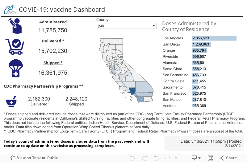
It is well-known that there are numerous logistical issues related to the manufacturing and equitable distribution of COVID-19 vaccines. That being said, the vaccines are slowly but surely making their way into all 58 counties in California. The official website for California Coronavirus Response provides many resources, including a COVID-19 state dashboard where cases, deaths, tests, and vaccine administration are shown in dashboard views. While many of us are quite familiar with dashboards for the daily and total cases, deaths, and tests, the  California COVID-19 Vaccine Dashboard is a relatively new addition to these data visualizations.

The vaccine administration dashboard is simple in nature. It displays the quantity of vaccine that has been shipped, delivered, and administered throughout all 58 counties in California. As depicted above, the CDC Pharmacy Partnership for Long-Term Care Program and CDC Federal Retail Pharmacy Program doses are a subset of the total. A live and interactive view of the dashboard is available here:

COVID-19 Vaccination: Is It My Turn?


As soon as the first COVID-19 vaccine was approved in December 2020, the state of California launched its “Vaccinate All 58” campaign with the aim of providing vaccinations for residents of all 58 California counties in a safe and equitable manner.

According to the campaign, “vaccines will be administered in phases by prioritizing groups according to risk and level of exposure. Initial doses will go to California’s essential health care workers and those among our most vulnerable in long-term care settings.” For more details, see the vaccine distribution plan and the Phase 1A vaccine distribution recommendations at the California Department of Public Health website.

While this background information may be interesting and useful to some, if you’re one of millions of Californians who are wondering when it will be your turn to get vaccinated, check out My Turn. According to the site, “Find out if it’s your turn by answering a few questions. It only takes a few minutes. If you’re eligible and vaccine appointments are available through My Turn, you can schedule one. If it’s not your turn yet or appointments are not available, you can register to be notified when you’re eligible or when appointments open up.”


I am not yet eligible for a COVID-19 vaccine, but I registered to be notified and will gladly schedule an appointment for the COVID-19 vaccine as soon as supplies become available for my demographic.

Friday, September 11, 2020

California Wildfires

The California Department of Forestry and Fire Protection (CAL FIRE) protects more than 31 million acres of California’s privately-owned wildlands by responding to all types of emergencies. This includes mostly fires but can also include floods, earthquakes, hazardous material spills, automobile accidents, child drownings, and other incidents. A full list of incidents is downloadable in .csv format here.

As the name CAL FIRE implies, most emergencies are related to wildfires. According to CAL FIRE, “Since the beginning of the year, wildfires have burned over 3.1 million acres in California. This year’s acres burned is 26 times higher than the acres burned in 2019 for the same time period.” Given the unprecedented impact of wildfires across California, I thought it would be useful to share a current map of incidents across California.

After navigating to an incident, you can view summary information such as this:

And depending on the impact of the incident, you may be able to view information related to damages and losses:

…and resources assigned:

Of noteworthy mention, the Resources page provides links to county-specific fire department websites where you may be able to obtain more information about fires in your county.